
About a nautical mile and a half further south of the southernmost tip of Mumbai, formerly Bombay, lies a lighthouse connected to Mumbai Island by a giant reef which opens out like a prong.
The charming aspect of this lighthouse is that for most of the year, this reef is not visible but a few times, during the perigean or king spring tides, Prong’s reef reveals itself as a mass of rocky land that can be traversed to reach Prong’s Lighthouse on foot. Visiting Prong’s Lighthouse was a dream that I clung to for several decades. After all, the southernmost tip of Mumbai Island presents a stunning view of the Arabian Sea if only you can get there. Being defence property, this is not typically accessible by civilians.

Imagine to my delight, when my cousin and childhood buddy Rajiv Mehrotra a.k.a. Raj managed to wrangle two passes for the bi-annual walk to the lighthouse. Well, this walk is reserved for family members of the defence forces but occasionally the Indian Navy gets magnanimous and permits civilian guests.
So, in the second half of May 2018, a life-long dream got fulfilled. Previously, I had sailed around Prong’s lighthouse but seeing the reef in its fully glory and setting foot on it was an altogether different affair.
About the Lighthouse
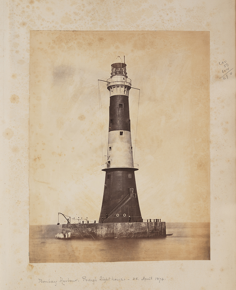
Completed in 1875 by Scottish engineer, Thomas Ormiston, Prong’s Lighthouse took several years to build. At a height of 41 metres, it is located strategically at the mouth of Mumbai harbour. It remains a manned lighthouse, one of very few offshore lighthouses that are staffed. Its light was upgraded in 1912 and now has a beam range of about 19 nautical miles.
(Source unknown)
The imperative for building this lighthouse lay in the more than 50 shipwrecks that took place around Bombay harbour during the 18th century. When construction finished it even had a cannon to ward off pirates.

Pic Credit Capt. Navtej Singh

Pic Credit Capt. Navtej Singh
The point on which the lighthouse stands, is guarded by an extensive reef of rocks and appears like a giant exclamation mark. A prong reef strikes the base of the lighthouse at its centre and hence the name of the reef and lighthouse. The prong is a dangerous one and leads directly to the lighthouse. It also forms the boundary of the entrance and the channel into Mumbai harbour.
The Walk
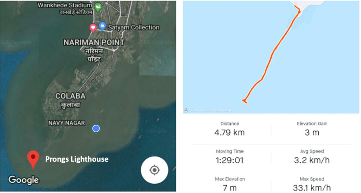
The access to Prong’s Lighthouse is from INS Kunjali, situated at the Southern tip of the promontory adjacent to the United Services Club. At the shore line of INS Kunjali is a small- to-modest patch of mangrove. On this particular day, this tiny slice of the Arabian Sea had parted to make way for a bunch of enthusiastic trekkers in a way that reminded me of the parting of the Red Sea by Moses. Here it was: a clear pathway, semi-cut and semi-smoothened for most able people, young and old to walk there.

Pic Credit: Rajiv Mehrotra

Pic Credit: Rajiv Mehrotra
The late Gulshan Rai, former President of the Royal Bombay Yacht Club had told me that his wife had once taken her infant on a perambulator all the way to the lighthouse. This seemed to me a rather adventurous act, for the path is slippery and wet. In fact, on one occasion on our return I had a mis-step which saw my back-side collide with the hard rock. Fortunately, there were no injuries.

who made our visit happen
Pic Credit: Rajiv Mehrotra
Overall, we took about an hour and thirty minutes to make the return journey of 4.8km and we spent about an hour at the lighthouse itself exploring the interiors and ascending to the very top storey which houses its remarkable light. The higher the level you climb to at the lighthouse the more breath-taking the view.


Pic Credit: Rajiv Mehrotra
Giving us constant company was a naval helicopter that kept hovering around us, keeping a hawk’s eye on our safety and progress. The Indian navy personnel were remarkably hospitable. They had set up stalls every hundred or two hundred metres. These were either educational in nature or they housed first-aid teams. When we got to the lighthouse, the Navy folks were gracious to offer us some snacks.
We returned back to shore in two hours and thirty minutes after we commenced our walk and headed straight to the sprawling lawns of INS Kunjali where a Navy Rear Admiral was addressing all these brave trekkers. What an incredible morning that was!
When we got home, my mind was racing as to whether and when I might be able to do this walk again but I took immense satisfaction in having being there no matter how ephemeral it was. I don’t know if I’ll have that opportunity again but what matters more is that the great people behind the Indian Navy consider making it easier for civilians to venture there. For the Indian Navy that would be a decision that lies on the prongs of a dilemma.
Feature Image Credit: Capt. Navtej Singh
Shakti Saran is a systems thinker, writer, consultant, and the Founder of Shaktify, an initiative to power changemakers
Discover more from Shakti's Musings: Blogs on everything under the sun
Subscribe to get the latest posts sent to your email.

Very well blogged. Lucky you to get this chance. Do inform if there’s another visit open to public.
LikeLiked by 1 person
Thank you. Do reach out to any Navy personnel in your circle. Some of them are happy to oblige.
LikeLike